On one side, deserts expanding.
On the other, lakes growing and restless volcanoes. Beneath our feet, something far larger is on the move.
Across eastern Africa, a quiet process-almost imperceptible on a human timescale-is redrawing the planet’s map. The ground is deforming, the crust is cracking, and tectonic plates are drifting apart by a few millimetres each year. Everything suggests that the African continent is, indeed, beginning to split in two-but on a timescale that stretches the imagination.
A continent in constant motion, even if it looks still
From the surface, continents seem like fixed, unchanging blocks. Geologically, the reality is very different. The lithosphere-the rigid outer layer that includes the Earth’s crust-floats on a more ductile mantle that moves slowly and continuously.
This motion is driven by plate tectonics: the set of processes that opens oceans, raises mountain ranges, and generates earthquakes. Africa, once part of the supercontinent Gondwana, remains caught in this deep dance that began hundreds of millions of years ago.
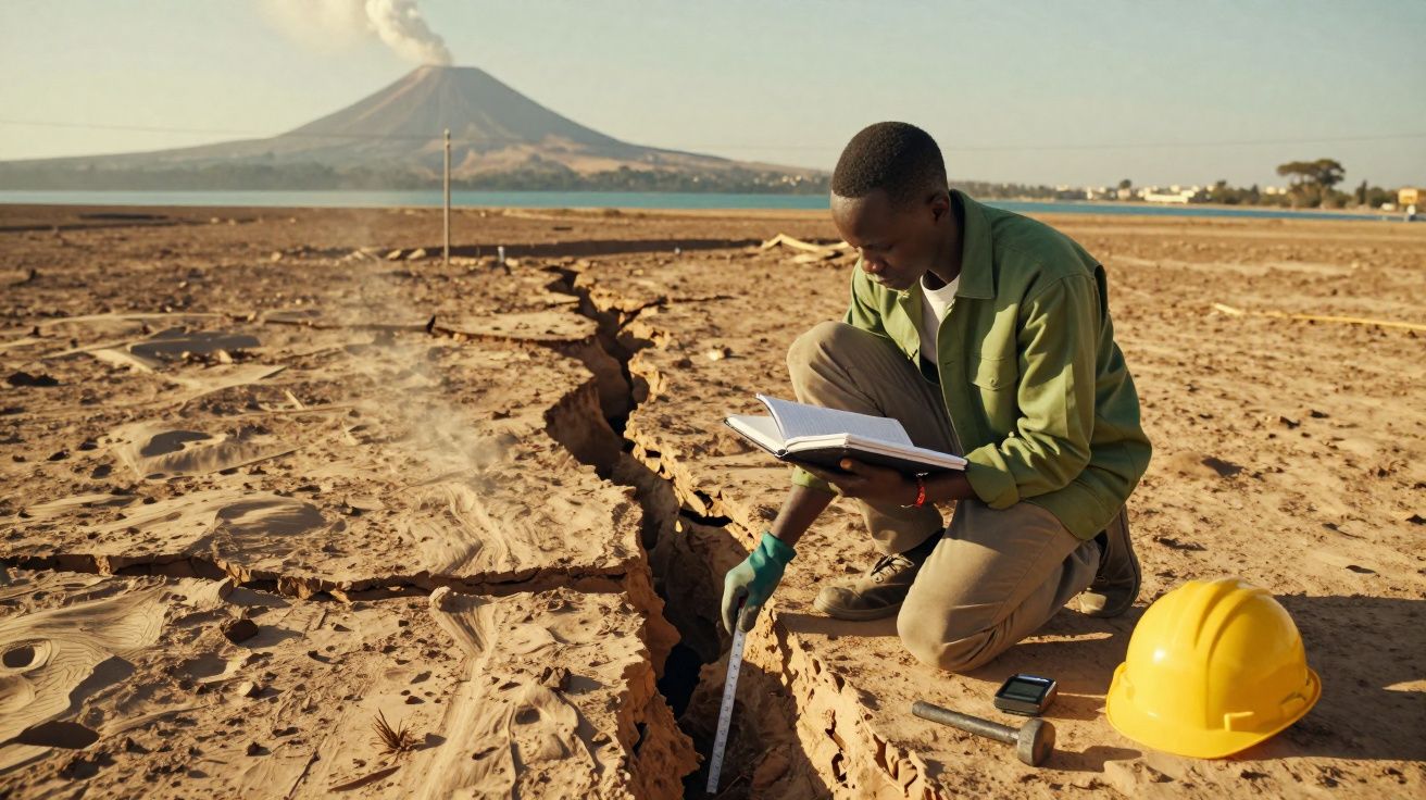
Beneath eastern Africa, that dance is becoming visible: cracks, active volcanoes and elongated lakes reveal the formation of a major continental fracture.
What we see today in countries such as Ethiopia, Kenya, Tanzania and Mozambique is a zone where the crust is being stretched. This region is known as the East African Rift: an immense tectonic valley running from the south of the continent up towards the Red Sea.
Afar: where three plates are pulling apart
In north-east Africa, in Ethiopia’s Afar region, lies one of the most geologically striking places on Earth. Here, three tectonic plates meet and move away from one another: the Arabian Plate, the Somali Plate and the Nubian Plate (which corresponds to Africa’s central “core”).
What is happening in eastern Africa
- The Somali Plate is moving at roughly 6 mm per year towards the south-east.
- Rifts and deep faults cut across the continent from Mozambique to the Red Sea.
- Afar concentrates volcanoes, lava fields and extensive surface fissures.
GPS measurements over recent decades confirm this millimetre-scale, yet steady, movement. The data indicate that the so-called Horn of Africa-covering Somalia, Ethiopia, Djibouti and part of Kenya-is slowly separating from the rest of the continent.
For geologists, the East African Rift is like an open-air laboratory, showing the earliest stages in the formation of a future ocean.
Studies published in scientific journals such as Tectonics compare today’s African setting with what happened when South America drifted away from Africa, creating the South Atlantic. The pattern repeats: first the continental crust stretches, then basins open, and only much later does true oceanic crust form.
From supercontinent to fragmented lands
The great fractures that cut through the crust do not only change the outlines of maps. They affect climate, ocean circulation and the distribution of plant and animal species.
When the Atlantic began to open more than 100 million years ago, continental margins that had once been joined pulled apart slowly. The result was the isolation of plants and animals, which then followed separate evolutionary paths. A similar process may be starting-at an early stage-in eastern Africa today.
A new ocean in the heart of Africa?
Geodynamic models cited by international science communication centres suggest a striking projection: in roughly 5 to 10 million years, the area now occupied by the Danakil Depression and sections of the Rift Valley could be flooded by seawater.
In that scenario, Somalia, Djibouti, Eritrea and parts of Kenya and Ethiopia would become a separate block, bounded to the west by a newly forming ocean. “Classic” Africa would lie on one side; a new set of lands-perhaps a microcontinent-on the other.
| Stage | What happens | Typical timescale |
|---|---|---|
| Crustal stretching | Faults form, intense volcanism, rift valleys develop | Tens of millions of years |
| Basin opening | Deep depressions begin to accumulate sediment and water | Millions to tens of millions of years |
| Ocean formation | Oceanic crust develops and a young sea spreads | Tens to hundreds of millions of years |
Volcanoes, lakes and cities on the fault
The signs of this geological change are already written into the landscape. The Rift Valley contains some of the deepest and longest lakes on the planet, such as Lakes Tanganyika and Malawi, aligned along major faults. These lakes occupy fissures where the crust has been stretched and has subsided.
Volcanic activity goes hand in hand with the process. Volcanoes such as Nyiragongo, Ol Doinyo Lengai and Erta Ale are fed by magma rising through these fractures. In Afar, recent lava fields, fumaroles and mineral-stained ground point to a subsurface in constant transformation.
On the surface, a tourist sees deserts and lakes; to a geologist, it is the “stitch line” of a future ocean emerging in slow motion.
Major cities already sit within this dynamic setting. Nairobi, Kampala, Addis Ababa and several regional capitals lie near faults or deformation zones. This increases the likelihood of moderate earthquakes, landslides and hazards associated with nearby volcanoes.
Risks, adaptation and the human timescale
Over a horizon of 5 to 10 million years, Africa’s split poses no direct danger to the current generation. A pace of a few millimetres a year is imperceptible within a lifetime. However, the associated phenomena-earthquakes, eruptions and ground deformation-already affect people living in the region.
Urban planners, engineers and civil protection authorities in East African countries need to account for this tectonic context in building standards, seismic monitoring and the management of high-risk areas. A practical example is reinforcing critical infrastructure-such as dams, roads, pipelines and power transmission lines-in zones with active faulting.
Key terms for understanding Africa’s separation
The topic often comes with technical language. Some terms help clarify what is at stake:
- Rift: a large, elongated valley or depression created when the crust is stretched and drops along parallel faults.
- Triple junction: a region where three tectonic plates meet and either move apart or collide, as in Afar.
- Somali Plate: the lithospheric block including eastern Africa, in the process of separating from the Nubian Plate.
- Microcontinent: a smaller continental mass isolated by oceans or seas that was once part of a larger landmass.
Geophysicists use supercomputers to simulate how these plates may interact over millions of years. The models take into account rock density, mantle temperature, the rate of crustal stretching and the legacy of older faults. From this, they outline scenarios ranging from the opening of a shallow sea to the formation of an ocean comparable to today’s Red Sea.
These projections help interpret present-day signals such as gravity anomalies, recurring small earthquakes and uplift of the ground. By combining these clues, a long-term story emerges: Africa-seemingly solid and indivisible-is slowly moving towards a future in which two distinct blocks will share a common origin, but follow different geological paths.


Comments
No comments yet. Be the first to comment!
Leave a Comment